| Sample Route Briefing for KFWA-KPVD |
| Log In |
|
|
THIS IS ONLY A SAMPLE BRIEFING. THIS IS NOT FOR NAVIGATION OR FOR PRE-FLIGHT PLANNING. The data shown here is outdated and should not be used for any purpose other than demonstrating the capabilities of the Weathermeister web site.
| Route of Flight | KFWA - KPVD |
|---|---|
| Total Distance | 621.1 nm |
| Initial Magnetic Course | 086° |
| Departure Time | Tue 9:00 AM EST |
| Best Speed Altitude | 17500' |
| Best Economy Altitude | 3500' |
| Flight Optimizer: Van's RV-7 N714D - LOP | ||||||||||||||||||||||||||||||||||||||||||||||||||||||||||||||||||||||||||||||||||||||||||||||||||||||||||||||||||||||||||||||
| ||||||||||||||||||||||||||||||||||||||||||||||||||||||||||||||||||||||||||||||||||||||||||||||||||||||||||||||||||||||||||||||
| ||||||||||||||||||||||||||||||||||||||||||||||||||||||||||||||||||||||||||||||||||||||||||||||||||||||||||||||||||||||||||||||
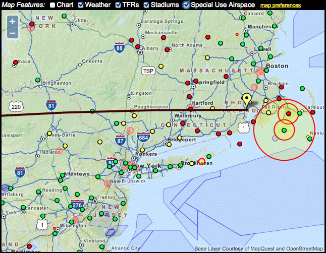
Active TFRs near the route KFWA-KPVD
| Date | NOTAM | Facility | State | Type | Description |
|---|---|---|---|---|---|
| 07/27/2007 | 7/0204 | ZDC | DC | SECURITY | Washington Center , Washington, DC, Thursday, August 30, 2007 Local |
| 07/27/2007 | 7/0206 | ZDC | DC | SECURITY | Washington Center , Washington, DC, Thursday, August 30, 2007 Local |
| 07/27/2007 | 7/0211 | ZDC | DC | SECURITY | Washington Center, Washington, DC, Thursday, August 30, 2007 Local |
| 11/22/2005 | 5/0860 | ZDC | MD | VIP | St. Michaels, MD, Wednesday, November 23, 2005 Local |
METARs within 25 nm of the route KFWA-KPVD show legend
change temperature
units
| Loc. | Time (EST) |
Cat. | Vis. | Wx. | Sky Cover |
Wind (Magnetic) |
Temp. | Dew Point |
Altim. | Hum. | Dens. Alt. |
Remarks |
|---|---|---|---|---|---|---|---|---|---|---|---|---|
| KFWA | 1:54 AM | VFR | 10 sm | Overcast 11000' | 320° at 3 kt | 48.0°F | 41.0°F | 30.07" | 77% | 241' | Sea level pressure 30.06" Hg | |
| KDFI | 1:53 AM | VFR | 6 sm | Mist | Broken 10000', Overcast 12000' | 320° at 3 kt | 48.0°F | 44.1°F | 30.05" | 86% | 144' | Sea level pressure 30.05" Hg |
| KAOH | 1:53 AM | VFR | 9 sm | Few 1800', Broken 8000', Overcast 11000' | Calm | 48.0°F | 45.0°F | 30.03" | 89% | 505' | Rain ended at 1:04 AM; Sea level pressure 30.02" Hg; Trace of precip since last report | |
| KFDY | 1:53 AM | MVFR | 3 sm | Mist | Few 2500', Scattered 9500' | 360° at 5 kt | 51.1°F | 46.9°F | 30.01" | 86% | 541' | Rain began at 12:54 AM, ended at 1:19 AM; Sea level pressure 30.00" Hg; Trace of precip since last report |
| KTDZ | 1:53 AM | VFR | 5 sm | Haze | Overcast 10000' | 350° at 5 kt | 53.1°F | 46.0°F | 30.03" | 77% | 408' | Sea level pressure 30.02" Hg |
| KLPR | 2:00 AM | IFR | 2 1/2 sm | Light Rain, Mist | Broken 800', Broken 1500', Overcast 8000' | 050° at 6 kt | 53.6°F | 51.8°F | 30.00" | 94% | 724' | Trace of precip since last report; Thunderstorm info not available |
| KCLE | 1:51 AM | MVFR | 4 sm | Mist | Few 900', Broken 8000', Overcast 12000' | 020° at 9 kt | 53.1°F | 48.9°F | 30.02" | 86% | 645' | Rain ended at 1:12 AM; Sea level pressure 30.02" Hg; Trace of precip since last report |
| KBKL | 1:53 AM | MVFR | 4 sm | Haze | Broken 8000' | 020° at 9 kt | 53.1°F | 48.0°F | 29.99" | 83% | 416' | Rain ended at 1:06 AM; Sea level pressure 29.99" Hg; Trace of precip since last report |
| KAKR | 2:05 AM | IFR | 2 1/2 sm | Light Rain, Mist | Scattered 1000', Broken 1500', Overcast 6500' | 030° at 6 kt | 53.6°F | 51.8°F | 29.98" | 94% | 1087' | 0.02" of precip since last report; Thunderstorm info not available |
| KCGF | 9:45 PM | MVFR | 3 sm | Rain, Mist | Broken 1500', Overcast 2000' | 240° at 12 kt | 59.0°F | 57.2°F | 29.96" | 94% | 1268' | |
| KYNG | 1:51 AM | IFR | 2 1/2 sm | Rain, Mist | Few 200', Broken 600', Overcast 1700' | 360° at 11 kt | 54.0°F | 51.1°F | 29.95" | 90% | 1300' | Sea level pressure 29.94" Hg; 0.1" of precip since last report |
| KHZY | 1:53 AM | MVFR | 4 sm | Mist | Few 2900', Scattered 10000' | Calm | 51.1°F | 48.0°F | 30.00" | 89% | 696' | Sea level pressure 30.00" Hg; Thunderstorm info not available |
| KUCP | 1:56 AM | MVFR | 5 sm | Light Rain, Mist | Scattered 700', Overcast 1300' | 350° at 6 kt | 55.9°F | 54.0°F | 29.96" | 93% | 1284' | Trace of precip since last report; Sea level pressure 30.00" Hg |
| KGKJ | 1:53 AM | MVFR | 4 sm | Mist | Overcast 2100' | 350° at 7 kt | 51.1°F | 46.9°F | 29.98" | 86% | 1304' | Rain ended at 1:29 AM; Sea level pressure 29.99" Hg; 0.07" of precip since last report; Thunderstorm info not available |
| KFKL | 1:55 AM | IFR | 6 sm | Broken 500', Broken 1100', Overcast 2100' | 330° at 6 kt | 53.6°F | 51.8°F | 29.98" | 94% | 1674' | 0.07" of precip since last report; 3-hour pressure trend steadily increased 0.01" Hg | |
| KDUJ | 1:56 AM | IFR | 2 sm | Light Rain, Mist | Scattered 300', Overcast 3300' | 260° at 8 kt | 51.1°F | 51.1°F | 29.92" | 100% | 1914' | Sea level pressure 29.93" Hg; 0.05" of precip since last report |
| KBFD | 1:53 AM | IFR | 5 sm | Light Rain, Mist | Broken 500', Overcast 1200' | 310° at 9 kt | 50.0°F | 48.9°F | 29.92" | 96% | 2234' | Ceiling variable 300-900'; Sea level pressure 29.93" Hg; 0.09" of precip since last report |
| KIPT | 1:54 AM | LIFR | 1 1/4 sm | Mist | Overcast 200' | Calm | 46.0°F | 44.1°F | 29.93" | 93% | -74' | Rain began at 1:37 AM, ended at 1:50 AM; Sea level pressure 29.93" Hg; Trace of precip since last report |
| KAVP | 1:54 AM | IFR | 1 1/2 sm | Light Rain, Mist | Overcast 500' | 220° at 3 kt | 46.9°F | 45.0°F | 29.92" | 93% | 542' | Rain began at 1:43 AM; Sea level pressure 29.91" Hg; Trace of precip since last report |
| KMSV | 1:55 AM | LIFR | 1 1/4 sm | Overcast 300' | Calm | 39.2°F | 32.0°F | 29.92" | 75% | 513' | ||
| KMGJ | 2:06 AM | IFR | 3 sm | Light Rain, Mist | Overcast 700' | Calm | 44.6°F | 42.8°F | 29.92" | 93% | -370' | 0.01" of precip since last report |
| KSWF | 9:45 PM | MVFR | 5 sm | Mist | Overcast 1500' | 230° at 5 kt | 44.6°F | 41.0°F | 30.05" | 87% | -370' | |
| KPOU | 1:53 AM | IFR | 2 sm | Light Rain, Mist | Scattered 700', Overcast 1400' | Calm | 44.1°F | 44.1°F | 29.93" | 100% | -662' | Rain began at 1:35 AM; Sea level pressure 29.92" Hg; 0.03" of precip since last report |
| KDXR | 1:53 AM | MVFR | 4 sm | Light Rain, Mist | Overcast 1000' | 250° at 4 kt | 46.0°F | 43.0°F | 29.95" | 89% | -190' | Rain began at 1:50 AM; Ceiling variable 800-1300'; Sea level pressure 29.95" Hg; Trace of precip since last report |
| KOXC | 1:55 AM | LIFR | 1 3/4 sm | Overcast 400' | 220° at 4 kt | 44.6°F | 42.8°F | 29.97" | 93% | 22' | ||
| KMMK | 1:53 AM | IFR | 2 1/2 sm | Mist | Overcast 800' | 160° at 3 kt | 46.9°F | 45.0°F | 29.95" | 93% | -562' | Rain ended at 1:40 AM; Ceiling variable 600-1000'; Sea level pressure 29.95" Hg; 0.01" of precip since last report |
| KBDL | 2:01 AM | IFR | 2 1/2 sm | Mist | Few 300', Overcast 1100' | 180° at 5 kt | 42.8°F | 39.2°F | 29.92" | 87% | -748' | |
| KHFD | 1:53 AM | IFR | 3 sm | Mist | Broken 700', Broken 1500', Overcast 2500' | 200° at 5 kt | 46.9°F | 44.1°F | 29.94" | 90% | -661' | Ceiling variable 500-1000'; Sea level pressure 29.94" Hg |
| KIJD | 1:52 AM | IFR | 2 1/2 sm | Mist | Few 300', Overcast 900' | Calm | 39.9°F | 37.0°F | 29.95" | 89% | -896' | Ceiling variable 600-1000'; Sea level pressure 29.95" Hg |
| KGON | 1:56 AM | MVFR | 5 sm | Light Rain, Mist | Broken 1000', Overcast 1500' | 270° at 12 gusting to 19 kt | 52.0°F | 48.9°F | 29.96" | 89% | -330' | Ceiling variable 600-1100'; Sea level pressure 29.95" Hg; 0.01" of precip since last report |
| KWST | 2:00 AM | LIFR | 2 sm | Light Rain, Mist | Broken 400', Overcast 900' | 250° at 7 kt | 51.8°F | 50.0°F | 29.96" | 94% | -246' | Ceiling variable 300-700'; 0.01" of precip since last report |
| KSFZ | 1:55 AM | LIFR | 1 3/4 sm | Overcast 300' | 240° at 5 kt | 46.4°F | 42.8°F | 29.92" | 87% | -154' | ||
| KUUU | 1:53 AM | IFR | 6 sm | Mist | Overcast 700' | 220° at 11 gusting to 19 kt | 51.1°F | 48.9°F | 29.95" | 92% | -176' | Rain ended at 1:35 AM; Ceiling variable 600-1200'; Sea level pressure 29.95" Hg; Trace of precip since last report |
| KTAN | 1:52 AM | MVFR | 6 sm | Haze | Overcast 1300' | 210° at 5 kt | 51.1°F | 46.0°F | 29.92" | 83% | -318' | Rain ended at 1:05 AM; Sea level pressure 29.92" Hg; Trace of precip since last report |
| KEWB | 1:53 AM | MVFR | 7 sm | Broken 1100', Overcast 1700' | 220° at 10 kt | 50.0°F | 48.9°F | 29.95" | 96% | -363' | Rain ended at 1:28 AM; Sea level pressure 29.94" Hg; 0.02" of precip since last report | |
| KPVD | 1:51 AM | IFR | 2 1/2 sm | Light Drizzle, Mist | Overcast 600' | 220° at 4 kt | 48.9°F | 46.0°F | 29.94" | 90% | -471' | Ceiling variable 600-1000'; Sea level pressure 29.94" Hg; Trace of precip since last report |
Pilot Reports within 25 nm of the route KFWA-KPVD (past 6 hours)
| Loc. | Time (CST) |
Altitude | Aircraft | Sky | Weather | Temp | Wind | Turbulence | Icing | Remarks |
|---|---|---|---|---|---|---|---|---|---|---|
| ISW | 9:48 PM | 34000' | B737 | Occasional Moderate to Severe Turbulence | ||||||
| GRB | 9:02 PM | 33000' | A320 | Continuous Light Occasional Moderate | ||||||
| AUW | 8:50 PM | 32000' | G5 | Moderate Chop | FL320 to FL370 |
 |
 |
| National Radar Mosaic | |||||||||||||||||||||||||||||||||||||||||||||||||||||||||||||||||||||||||||||||||||||||||||||||||||||||||||||||||
 | |||||||||||||||||||||||||||||||||||||||||||||||||||||||||||||||||||||||||||||||||||||||||||||||||||||||||||||||||
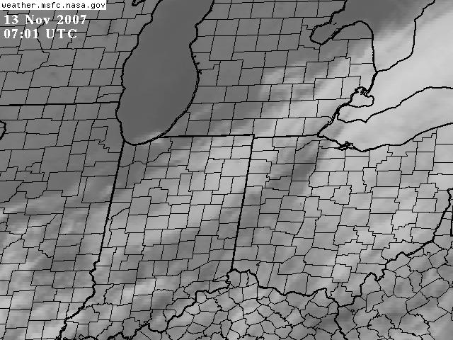
GOES Satellite View of KFWA
 | |||||
|
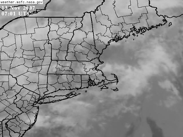
GOES Satellite View of KPVD
 | |||||
|
 | |||||
|
 | |||||||||||
|
 | |||||||||||||||
|
 |
34000' | |
| 18000' | ||
| 10000' | ||
| 5000' | ||
| Surface |
| |||||||||||||||||||||||||||||||||||||||||||||||||||||||||||||||||||||
| NOTE: This interpolation does not account for wind correction angle. |
Sunrise/Sunset Data
| Morning Twilight |
Sunrise | Sunset | Evening Twilight |
Moonrise | Moonset | Illumination 9:00 AM EST | |
|---|---|---|---|---|---|---|---|
| KFWA | 6:56 AM EST | 7:26 AM EST | 5:24 PM EST | 5:53 PM EST | 11:08 AM EST | 7:48 PM EST | 12% waxing |
| KPVD | 6:02 AM EST | 6:32 AM EST | 4:27 PM EST | 4:58 PM EST | 10:15 AM EST | 6:48 PM EST | 12% waxing |
TAFs within 25 nm of the route KFWA-KPVD show legend
| Loc. | Reports (all times EST) |
|---|---|
| KFWA | Reported: November 13, 2007 at 12:37
AM Valid From: November 13, 2007 at 1:00 AM Valid Until: November 14, 2007 at 1:00 AM |
| KFDY | Reported: November 13, 2007 at 12:26
AM Valid From: November 13, 2007 at 1:00 AM Valid Until: November 14, 2007 at 1:00 AM |
| KCLE | Reported: November 13, 2007 at 12:26
AM Valid From: November 13, 2007 at 1:00 AM Valid Until: November 14, 2007 at 1:00 AM |
| KYNG | Reported: November 13, 2007 at 12:26
AM Valid From: November 13, 2007 at 1:00 AM Valid Until: November 14, 2007 at 1:00 AM |
| KFKL | Reported: November 13, 2007 at 12:20
AM Valid From: November 13, 2007 at 1:00 AM Valid Until: November 14, 2007 at 1:00 AM |
| KDUJ | Reported: November 13, 2007 at 12:20
AM Valid From: November 13, 2007 at 1:00 AM Valid Until: November 14, 2007 at 1:00 AM |
| KBFD | Reported: November 13, 2007 at 12:42
AM Valid From: November 13, 2007 at 1:00 AM Valid Until: November 14, 2007 at 1:00 AM |
| KIPT | Reported: November 13, 2007 at 12:42
AM Valid From: November 13, 2007 at 1:00 AM Valid Until: November 14, 2007 at 1:00 AM |
| KAVP | Reported: November 13, 2007 at 12:20
AM Valid From: November 13, 2007 at 1:00 AM Valid Until: November 14, 2007 at 1:00 AM |
| KSWF | Reported: November 13, 2007 at 12:27
AM Valid From: November 13, 2007 at 1:00 AM Valid Until: November 14, 2007 at 1:00 AM |
| KPOU | Reported: November 13, 2007 at 12:32
AM Valid From: November 13, 2007 at 1:00 AM Valid Until: November 14, 2007 at 1:00 AM |
| KBDL | Reported: November 13, 2007 at 1:15
AM Valid From: November 13, 2007 at 1:00 AM Valid Until: November 14, 2007 at 1:00 AM |
| KGON | Reported: November 13, 2007 at 12:27
AM Valid From: November 13, 2007 at 1:00 AM Valid Until: November 14, 2007 at 1:00 AM |
| KPVD | Reported: November 13, 2007 at 2:02
AM Valid From: November 13, 2007 at 2:00 AM Valid Until: November 14, 2007 at 1:00 AM |
NWS Forecast for KFWA
| Day/Time (EST) |
Temp. | Dew Pt. | Humid. | Approx. Dens. Alt. |
Wind | Cloud Cover |
Precip Chance |
Weather | |
|---|---|---|---|---|---|---|---|---|---|
| Tuesday 4:00AM |
49°F | 44°F | 83% | 500' | 002° 5-6 knots |
85% | 99% | ||
| Tuesday 7:00AM |
46°F | 43°F | 89% | 300' | 026° 5-6 knots |
68% | 5% | ||
| Tuesday 10:00AM |
47°F | 41°F | 80% | 300' | 080° 5 knots |
61% | 5% | ||
| Tuesday 1:00PM |
57°F | 42°F | 57% | 1000' | 134° 6-7 knots |
39% | 5% | ||
| Tuesday 4:00PM |
61°F | 43°F | 52% | 1300' | 140° 6 knots |
33% | 5% |
NWS Forecast for KPVD
| Day/Time (EST) |
Temp. | Dew Pt. | Humid. | Approx. Dens. Alt. |
Wind | Cloud Cover |
Precip Chance |
Weather | |
|---|---|---|---|---|---|---|---|---|---|
| Tuesday 4:00AM |
44°F | 43°F | 96% | -800' | 220° 8-9 knots |
100% | 92% | Definitely light rain showers, visibility 5 miles | |
| Tuesday 7:00AM |
44°F | 44°F | 100% | -800' | 234° 7-8 knots |
100% | 72% | Definitely light rain showers, visibility 5 miles | |
| Tuesday 10:00AM |
52°F | 42°F | 69% | -300' | 290° 9-12 knots |
81% | 72% | Chance of light rain showers, visibility 5 miles | |
| Tuesday 1:00PM |
57°F | 39°F | 51% | 100' | 320° 10-17 knots |
13% | 72% | ||
| Tuesday 4:00PM |
56°F | 37°F | 49% | 0' | 314° 9-13 knots |
72% |
Chicago Area Forecast
000 FAUS43 KKCI 130245 FA3W CHIC FA 130245 SYNOPSIS AND VFR CLDS/WX SYNOPSIS VALID UNTIL 132100 CLDS/WX VALID UNTIL 131500...OTLK VALID 131500-132100 ND SD NE KS MN IA MO WI LM LS MI LH IL IN KY . SEE AIRMET SIERRA FOR IFR CONDS AND MTN OBSCN. TS IMPLY SEV OR GTR TURB SEV ICE LLWS AND IFR CONDS. NON MSL HGTS DENOTED BY AGL OR CIG. . SYNOPSIS...CDFNT EXTDS FM SE ONT-NRN IN-SRN IL TO WK LOW OVR SW MO..CONTG THRU CNTRL OK-NW TX. CDFNT WL MOV SLOLY SEWD TO EXTD FM WV-SW KY-WRN AR BECMG STNR TO NW TX BY 18Z. RDG HI PRES FM WRN KS TO WI WL MOV EWD AND WKN. PAC CDFNT OVR THE PAC NW AND NRN RCKYS WL MOV ESEWD TO EXTD FM SW ONT-SW SD-SW WY BY 18Z. . ND BKN CI. BECMG 08-12Z SCT-BKN120 BKN CI. OTLK...VFR WND. . SD WRN...BKN CI. OTLK...VFR. ERN...SKC. BECMG 09-12Z BKN CI. OTLK...VFR. . NE SRN...BKN-SCT150 BKN CI. BECMG 03-05Z SCT CI. OTLK...VFR. NRN/PNHDL...SKC. BECMG 06-10Z SCT-BKN CI. OTLK...VFR. . KS S CNTRL/SERN...CIG BKN30. TOPS 080. BECMG 08-11Z CIG BKN-SCT040. OTLK...VFR. SWRN...SKC. OTLK...VFR. NRN...SCT-BKN150 BKN CI. BECMG 04-07Z SCT CI. OTLK...VFR. . MN NRN...SCT CI. 06-09Z BKN CI. OTLK...VFR WND. SRN...SKC. 11Z SCT CI. OTLK...VFR WND. . IA NRN...SCT CI. OTLK...VFR. SRN...SCT120 SCT-BKN CI. 06Z SCT CI. OTLK...VFR. . MO CNTRL/SRN...AGL SCT-BKN010-020 CIG BKN050. TOPS 150. WDLY SCT - SHRA/-TSRA. CB TOPS FL350. BECMG 08-12Z CIG BKN010-020 OVC050. TOPS 090. OCNL VIS 3-5SM BR. OTLK...MVFR CIG SRN MO..VFR CNTRL MO. NRN...BKN-SCT080. BECMG 06-09Z SCT CI. OTLK...VFR. . WI SRN...BKN-SCT100 BKN CI. 06Z SKC. OTLK...VFR. NRN...SKC OR SCT CI. OTLK...VFR WND. . LS UPR MI SKC OR SCT CI. BECMG 06-10Z SCT-BKN CI. OTLK...VFR WND. . LM LWR MI LH NRN SXNS...BKN150 BKN CI. 05Z SKC. 12Z BKN CI. OTLK...VFR. SWRN SXNS...BKN150 BKN CI. OCNL VIS 3-5SM BR. BECMG 06-09Z SCT150. OCNL VIS 3-5SM BR. OTLK...VFR. SERN SXNS...CIG BKN-SCT015-025 BKN120. OCNL VIS 3-5SM BR. BECMG 06-09Z SCT150. OCNL VIS 3-5SM BR. OTLK...VFR. . IL SRN...CIG BKN010-020 OVC080. TOPS 160. OCNL VIS 3-5SM -SHRA BR. ISOL -TSRA. CB TOPS FL350. BECMG 09-12Z CIG BKN010-020 OVC050. TOPS 090. OCNL VIS 3-5SM BR. OTLK...MVFR CIG. CNTRL...CIG BKN-SCT030-050 BKN100. TOPS 150. WDLY SCT-SHRA. BECMG 06-09Z AGL SCT050 BKN-SCT120. OCNL VIS 3-5SM BR. OTLK...VFR. NRN...BKN100 BKN CI. BECMG 06-09Z SCT CI. OTLK...VFR. . IN NRN...CIG BKN010-020 OVC080. TOPS FL180. OCNL VIS 3-5SM -SHRA BR. BECMG 06-09Z AGL SCT040 BKN150. OCNL VIS 3-5SM BR. 12Z SCT CI. OTLK...VFR. CNTRL/SRN...CIG BKN010-020 OVC080. TOPS FL200. OCNL VIS 3-5SM -RA BR. ISOL -TSRA. CB TOPS FL350. BECMG 09-13Z CIG BKN010-020 OVC050. TOPS 120. WDLY SCT -SHRA. OCNL VIS 3-5SM BR. OTLK...MVFR CIG SRN IN..VFR CNTRL IN. . KY WRN/N CNTRL...CIG BKN030-050 BKN100. WDLY SCT -SHRA. BECMG 06-09Z CIG BKN010-020 OVC080. TOPS FL200. OCNL VIS 3-5SM -SHRA BR. ISOL -TSRA. CB TOPS FL350. OTLK...IFR CIG SHRA BR BECMG AFT 18Z MVFR CIG. ERN/S CNTRL...AGL SCT-BKN050 BKN100. ISOL -SHRA. BECMG 09-12Z CIG BKN020-030 OVC080. TOPS FL200. OCNL VIS 3-5SM -SHRA BR. OTLK...MVFR CIG SHRA BR. .... |
Boston Area Forecast
000 FAUS41 KKCI 130145 FA1W BOSC FA 130145 SYNOPSIS AND VFR CLDS/WX SYNOPSIS VALID UNTIL 132000 CLDS/WX VALID UNTIL 131400...OTLK VALID 131400-132000 ME NH VT MA RI CT NY LO NJ PA OH LE WV MD DC DE VA AND CSTL WTRS . SEE AIRMET SIERRA FOR IFR CONDS AND MTN OBSCN. TS IMPLY SEV OR GTR TURB SEV ICE LLWS AND IFR CONDS. NON MSL HGTS DENOTED BY AGL OR CIG. . SYNOPSIS...02Z OCLD FNT 100NW YOW-70SW YOW. CDFNT 70SW YOW-50E YYZ-CLE-40W ROD LN CONTG WSWWD. WRMFNT 70SW YOW-60NE SLT-SBY- 60SSE SBY LN. 20Z OCLD FNT FM LOW 70NE YSJ TO 180S YSJ. CDFNT 180S YSJ-160ESE ACK-150SE SIE-ORF-LYH LN. STNR FNT LYH-40WSW BKW LN CONTG WWD. HIGH NR ERI. . ME NH VT NRN ME...BKN CI. BECMG 0305 OVC080 TOP FL200. BECMG 0709 OVC030. VIS 3-5SM -SN BR. OTLK...MVFR CIG SHSN. VT/NRN NH...OVC030 TOP FL250. SCT SHRA. 08Z OVC025. VIS 3-5SM BR. WDLY SCT SHRA. OTLK...MVFR CIG BR BECMG AFT 17Z VFR. SWRN ME/SRN NH...OVC040 TOP FL250. OCNL BKN025. AFT 04Z SCT SHRA. 09Z OVC015. SCT SHRA. OTLK...MVFR CIG SHRA BECMG AFT 17Z VFR. SERN ME...BKN CI. BECMG 0204 OVC040 TOP FL250. AFT 08Z SCT SHRA. 10Z OVC015. VIS 3-5SM -RA BR. OTLK...MVFR CIG RA BR. . MA RI CT CT/WRN AND CNTRL MA...OVC020 TOP LYRD FL250. BECMG 0204 OVC015. SCT SHRA. OTLK...MVFR CIG SHRA BECMG AFT 16Z VFR. RI/ERN MA...OVC020 TOP LYRD FL250. BECMG 0406 OVC015. SCT SHRA. OTLK...MVFR CIG SHRA BECMG AFT 18Z VFR. . NY LO LO/WRN AND S CNTRL NY...OVC025 TOP LYRD FL220. SCT SHRA. ISOL TSRA. CB TOP FL300. OCNL VIS 3-5SM BR. BECMG 0305 OVC020-030. VIS 3-5SM BR. BECMG 1012 BKN030 TOP 080. VIS 3-5SM BR. OTLK...VFR. N CNTRL/NERN NY...OVC040 TOP FL220. OCNL VIS 3-5SM -RA BR. 06Z OVC030. VIS 3-5SM BR. OCNL -RA/-DZ. BECMG 1012 OVC030 TOP 080. OCNL VIS 3-5SM BR. OTLK...VFR. EXTRM SERN NY/LONG ISLAND...BKN020 OVC080 TOP LYRD FL250. BECMG 0204 OVC020. SCT SHRA. OTLK...MVFR CIG SHRA BECMG AFT 16Z VFR. RMNDR... OVC030 TOP FL250. SCT SHRA. OCNL VIS 3-5SM BR. OTLK...VFR. . PA NJ NRN PA...OVC030 TOP FL250. SCT SHRA/WDLY SCT TSRA. CB TOP FL300. 12Z OVC030 TOP 100. OTLK...VFR. SWRN/S CNTRL PA...BKN100 TOP FL250. OCNL OVC040 WITH WDLY SCT SHRA/ISOL TSRA. CB TOP FL300. 04Z OVC030. VIS 3-5SM -RA BR. ISOL TSRA. OTLK...MVFR CIG BR BECMG AFT 15Z VFR. NRN NJ/SERN PA...OVC020 TOP FL250. VIS 3-5SM SCT SHRA/ISOL TSRA. CB TOP FL300. OTLK...MVFR CIG SHRA BECMG AFT 16Z VFR. SRN NJ...SCT030 BKN060 TOP FL250. OCNL BKN025 WITH WDLY SCT SHRA. 10Z BKN025. ISOL SHRA. OTLK...MVFR CIG SHRA. 17Z VFR. . OH LE LE/NRN OH...OVC020 TOP LYRD FL250. VIS 3-5SM -RA BR. ISOL TSRA. CB TOP FL300. BECMG 0608 OVC030. ISOL SHRA. BECMG 1113 SCT-BKN030 TOP 100. OTLK...VFR. SRN OH...OVC050 TOP LYRD FL250. WDLY SCT SHRA/ISOL TSRA. CB TOP FL300. BECMG 0305 OVC030. OCNL VIS 3-5SM -RA BR. ISOL TSRA. OTLK...MVFR CIG SHRA BECMG AFT 18Z VFR. . WV MD DC DE VA W OF THE APLCNS...OVC060 TOP FL220. BECMG 0406 OVC030. OCNL VIS 3-5SM -RA BR. ISOL TSRA. CB TOP FL300. OTLK...MVFR CIG RA BR BECMG AFT 19Z VFR NRN 1/2. MVFR CIG RA BR SRN 1/2. NRN 2/3 APLCNS...OVC070 TOP FL220. BECMG 0709 OVC040. SCT SHRA/ISOL TSRA. CB TOP FL300. OTLK...MVFR CIG RA BR. SRN 1/3 APLCNS...SCT050 BKN070 TOP FL220. BECMG 1012 BKN040 OVC060. SCT SHRA. OTLK...MVFR CIG SHRA. S CNTRL/SERN VA...SCT-BKN100 TOP FL220. BECMG 0709 BKN060 OVC100. AFT 12Z WDLY SCT SHRA. OTLK...VFR SHRA. DC/DE/RMNDR MD/RMNDR VA...BKN060 OVC100 TOP FL220. BECMG 1012 BKN040 OVC060. WDLY SCT SHRA. OTLK...VFR SHRA. . CSTL WTRS E OF ENE-140E ACK LN...BKN CI. 03Z OVC040 TOP FL250. BECMG 0810 OVC020. VIS 3-5SM -RA BR. OTLK...MVFR CIG RA BR. RMNDR N OF 40N...OVC040 TOP LYRD FL250. AFT 03Z OCNL BKN020 WITH SCT SHRA WRN 1/2. 08Z OVC020. SCT SHRA. OTLK...MVFR CIG SHRA. VA...SCT-BKN040 TOP 100. 04Z BKN100 TOP FL220. 12Z BKN040 OVC100. OTLK...VFR SHRA. RMNDR...OVC040 TOP LYRD FL250. AFT 08Z WDLY SCT SHRA. OTLK...VFR SHRA. .... |
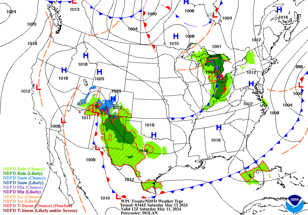
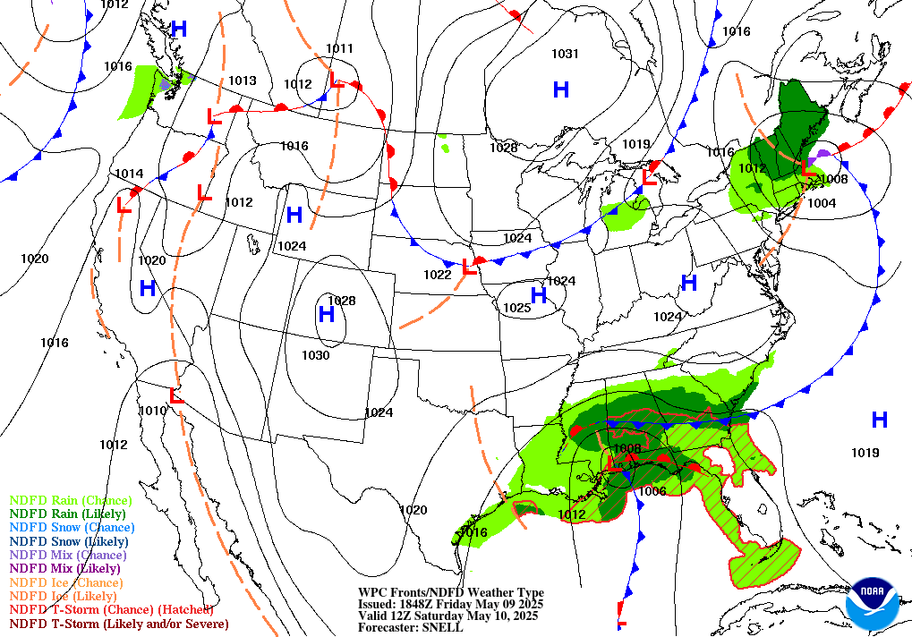
| 12 Hour Fronts/Precipitation | 24 Hour Fronts/Precipitation | 36 Hour Fronts/Precipitation | 48 Hour Fronts/Precipitation |
 |
 |
 |
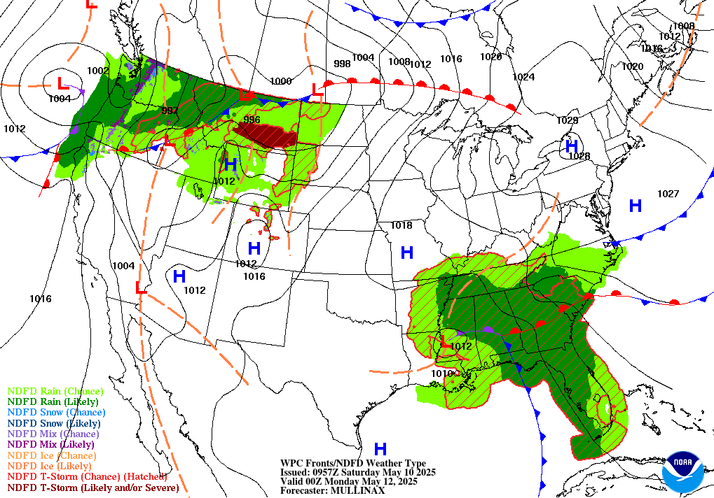 |
| Day 3 Fronts/Pressure | Day 4 Fronts/Pressure | Day 5 Fronts/Pressure | Day 6 Fronts/Pressure |
 |
 |
 |
 |
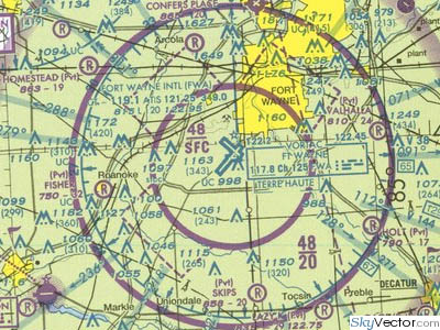
NOTAMs within 25 nm of the route KFWA-KPVD Show FDC NOTAMs NOTE: times
shown are typically UTC
| Loc. | Number | Description |
|---|---|---|
| KFWA | 04/032 | TACAN Azimuth 170-210 Unusable Beyond 22/Below 4000 27 APR 14:25 2006 Until Further Notice |
| 05/015 | 5/23 150 WIDE 130 GROOVED Instead of/Versus 130 WIDE 15 MAY 19:00 2007 Until Further Notice | |
| 08/026 | 32 HOAGY NDB/ILS Compass Locator at ILS Outer Marker Unmonitored Effective Immediately Until Further Notice | |
| 08/030 | 32 ILS Middle Marker Decommissioned 30 AUG 17:00 2006 Until Further Notice | |
| 11/002 | 32 ILS Localizer NOW 1T CLASSIFICATION Effective Immediately Until Further Notice | |
| KSMD | 11/046 | TOWER 1627 (806 AGL) 2.84 SW Lights Out of Service (Antenna Structure Registration 1034986) Effective Immediately Until 20 NOV 22:56 2007 |
| 11/080 | TOWER 1523 (703 AGL) 3.12 SW Lights Out of Service (Antenna Structure Registration 1238203) Effective Immediately Until 09 NOV 21:38 2007 Effective Immediately Until 24 NOV 21:38 2007 | |
| KHHG | 11/053 | TOWER 1077 (259 AGL) 3.74 SE Lights Out of Service (Antenna Structure Registration 1053042) Effective Immediately Until 21 NOV 07:44 2007 |
| 0G6 | 10/335 | TOWER 1075 (335 AGL) 10.07 E Lights Out of Service (Antenna Structure Registration 1015721) Effective Immediately Until 14 NOV 20:43 2007 |
| 11/038 | TOWER 1249 (348 AGL) 13.16 N Lights Out of Service (Antenna Structure Registration 1031365) Effective Immediately Until 19 NOV 21:48 2007 | |
| KOWX | 03/291 | AWOS 419-523-4151 Instead of/Versus 419-523-1451 Effective Immediately Until Further Notice |
| KAOH | 11/003 | TOWER 1088 (316 AGL) 14.10 NW Lights Out of Service (Antenna Structure Registration 1014144) Effective Immediately Until 24 NOV 07:21 2007 |
| 11/004 | VOR Out of Service 15 NOV 13:00 2007 Until 15 NOV 19:00 2007 | |
| KFDY | 11/004 | TOWER 1042 (260 AGL) 2.75 E Lights Out of Service (Antenna Structure Registration 1221313) Effective Immediately Until 25 NOV 01:38 2007 |
| 11/006 | VORTAC Out of Service 14 NOV 13:00 2007 Until 14 NOV 19:00 2007 | |
| 1G0 | 11/134 | TOWER 914 (255 AGL) 4.42 NNE Lights Out of Service (Antenna Structure Registration 1204339) Effective Immediately Until 25 NOV 22:53 2007 |
| KTDZ | 11/001 | ANTENNA Unknown (241 AGL) 6 SE Lights Out of Service Effective Immediately Until 07 DEC 23:59 2007 |
| 56D | 10/328 | TOWER 1151 (265 AGL) 11.75 SSW Lights Out of Service (Antenna Structure Registration 1248012) Effective Immediately Until 14 NOV 12:23 2007 |
| 16G | 09/076 | AWOS 127.175/419-443-1043 Commissioned Effective Immediately Until Further Notice |
| KPCW | 10/311 | 9/27 Closed Effective Immediately Until Further Notice |
| 10/313 | 18/36 Closed PLA/TGL 29 OCT 14:50 2007 Until Further Notice | |
| 3G4 | 11/138 | TOWER 1322 (285 AGL) 2.38 SE Lights Out of Service (Antenna Structure Registration 1215424) Effective Immediately Until 26 NOV 12:14 2007 |
| KLPR | 02/063 | OBRLN ONE DEPARTURE. FORT WAYNE TRANSITION Not Authorized. 07 FEB 00:01 2007 Until Further Notice |
| 06/030 | ABERZ1 ARRIVAL DQN TRANSITION Not Authorized. Effective Immediately Until Further Notice | |
| 06/035 | CXR1 ARRIVAL ... JHW TRANSITION Not Authorized. Effective Immediately Until Further Notice | |
| 1G1 | 02/008 | OBRLN ONE DEPARTURE ... FORT WAYNE TRANSITION Not Authorized 07 FEB 00:00 2007 Until Further Notice |
| 06/033 | ABERZ1 ARRIVAL DQN TRANSITION Not Authorized. Effective Immediately Until Further Notice | |
| 06/034 | CXR1 ARRIVAL ... JHW TRANSITION Not Authorized. Effective Immediately Until Further Notice | |
| KCLE | 02/121 | OBERLIN1 FWA TRANSITION N/A Effective Immediately Until Further Notice |
| 02/198 | AMRST ONE DEPARTURE...CRL TRANSITION Not Authorized AOA FL230. Effective Immediately Until Further Notice | |
| 03/160 | OBRLN ONE DEPARTURE... ALPHE ONE DEPARTURE... AMRST ONE DEPARTURE... SANDUSKY ONE DEPARTURE... DEPARTURE ROUTE DESCRIPTION, TAKE-OFF RUNWAYS 6L, 6R, 10: CHANGE ...CLIMBING LEFT TURN INBOUND TO DJB VOR/DME By Way Of R-082 TO 2600, THEN By Way Of ASSIGNED HEADING TO 5000 THENCE... TO READ: ...CLIMB By Way Of ASSIGNED HEADING TO 5000 THENCE...REST REMAINS UNCHANGED Effective Immediately Until Further Notice | |
| 04/128 | AMRST ONE DEPARTURE ... CARLETON TRANSITION Not Authorized AT OR ABOVE FL230. Effective Immediately Until Further Notice | |
| 04/338 | 24L ILS Outer Marker Decommissioned 26 APR 12:00 2007 Until Further Notice | |
| 05/268 | 24L LDA Localizer Glide Path Out of Service 22 MAY 00:01 2007 Until 20 NOV 00:01 2008 | |
| 05/288 | 6R Approach Lighting System Out of Service 22 MAY 01:50 2007 Until Further Notice | |
| 06/027 | ABERZ1 ARRIVAL ... DQN TRANSITION Not Authorized. Effective Immediately Until Further Notice | |
| 06/031 | CXR1 ARRIVAL ... JHW TRANSITION Not Authorized. Effective Immediately Until Further Notice | |
| 07/208 | 6R LDA Out of Service 19 JUL 09:00 2007 Until Further Notice | |
| 07/210 | 6R ILS Outer Marker Out of Service 19 JUL 09:00 2007 Until Further Notice | |
| 07/212 | 24L Approach Lighting System Out of Service 19 JUL 09:00 2007 Until Further Notice | |
| 10/129 | 6R ILS Out of Service Effective Immediately Until 14 NOV 23:59 2007 | |
| 10/130 | 24L ILS Out of Service Effective Immediately Until 14 NOV 23:59 2007 | |
| 10/216 | 6R/24L Closed Effective Immediately Until 18 NOV 10:00 2007 | |
| 11/072 | TOWER 2049 (1030 AGL) 6.85 ESE Lights Out of Service (Antenna Structure Registration 1012992) Effective Immediately Until 22 NOV 13:51 2007 | |
| 11/142 | Terminal Doppler Weather Radar Out of Service 14 NOV 16:00 2007 Until 14 NOV 21:00 2007 | |
| 11/152 | Terminal Doppler Weather Radar Out of Service 15 NOV 16:00 2007 Until 15 NOV 21:00 2007 | |
| A0826/06 | STANDARD INSTRUMENT ARRIVAL (Standard Terminal Arrival Route) NOT AVAILABLE ABERZ1 ARRIVAL ... DQN TRANSITION Not Authorized. Effective Immediately Until Further Notice | |
| A0827/06 | STANDARD INSTRUMENT ARRIVAL (Standard Terminal Arrival Route) NOT AVAILABLE CXR1 ARRIVAL ... JHW TRANSITION Not Authorized. Effective Immediately Until Further Notice | |
| A0832/07 | STANDARD INSTRUMENT DEPARTURE (Standard Instrument Departure) OBERLIN1 FWA TRANSITION N/A Effective Immediately Until Further Notice | |
| A0946/07 | INSTRUMENT APPROACH PROCEDURE CHANGED RNAV (GPS) Runway 10, Original... TERMINAL ROUTE GONNE TO TAMDE TO FIMOL Not Authorized. Effective Immediately Until Further Notice | |
| A0949/07 | STANDARD INSTRUMENT DEPARTURE (Standard Instrument Departure) AMRST ONE DEPARTURE...CRL TRANSITION Not Authorized AOA FL230. Effective Immediately Until Further Notice | |
| A1026/07 | INSTRUMENT APPROACH PROCEDURE CHANGED ILS Runway 28, Amendment 22... CHANGE PLANVIEW NOTE 3000 WHEN AUTHORIZED BY Air Traffic Control TO READ 4000 WHEN AUTHORIZED BY Air Traffic Control. Effective Immediately Until Further Notice | |
| A1092/07 | STANDARD INSTRUMENT DEPARTURE (Standard Instrument Departure) OBRLN ONE DEPARTURE... ALPHE ONE DEPARTURE... AMRST ONE DEPARTURE... SANDUSKY ONE DEPARTURE... DEPARTURE ROUTE DESCRIPTION, TAKE-OFF RUNWAYS 6L, 6R, 10: CHANGE ...CLIMBING LEFT TURN INBOUND TO DJB VOR/DME By Way Of R-082 TO 2600, THEN By Way Of ASSIGNED HEADING TO 5000 THENCE... TO READ: ...CLIMB By Way Of ASSIGNED HEADING TO 5000 THENCE...REST REMAINS UNCHANGED Effective Immediately Until Further Notice | |
| A1339/07 | OUTER MARKER (ILS) 24L 26 APR 12:00 2007 Until Further Notice | |
| A1427/07 | LOCALIZER (ILS) UNSERVICEABLE Runway 24L LOCALIZER TYPE DIRECTIONAL AID Localizer Glide Path U/S 22 MAY 00:01 2007 Until 20 NOV 00:01 2008 | |
| A1436/07 | APPROACH LIGHTING SYSTEM UNSERVICEABLE 06R 22 MAY 01:50 2007 Until Further Notice | |
| A1451/07 | ILS Runway 6R (Category II), Amendment 19C... ILS Runway 6R (Category III), Amendment 19C... RNAV (GPS) Runway 6R, Amendment 1A... LDA/DME Runway 6R, Original... LDA PRM Runway 6R (SIMULTANEOUS CLOSE PARALLEL), ORIG-B... PROCEDURE Not Authorized. Effective Immediately Until Further Notice | |
| A1452/07 | ILS OR LOC Runway 6R, Amendment 19C... S-ILS MINIMUMS Not Authorized. SIDESTEP 6C, SIDESTEP 6L MINIMUMS Not Authorized. S-LOC 6R Minimum Descent Altitude 1160/HAT 383 ALL Category. Visibility Runway Visual Range 5000 ALL Categories. Final Approach Fix TO Missed Approach Point 6.3 NM. 60 KNOTS: 6 MIN 20 SEC, 90 KNOTS: 4 MIN 13 SEC, 120 KNOTS: 3 MIN 10 SEC, 150 KNOTS: 2 MIN 32 SEC, 180 KNOTS: 2 MIN 7 SEC. Effective Immediately Until Further Notice | |
| A1479/07 | INSTRUMENT APPROACH PROCEDURE CHANGED RNAV (GPS) Runway 24L, Amendment 1... LNAV/VNAV Decision Altitude 1285/HAT 499 ALL Categories. Visibility 6000 ALL Categories. Effective Immediately Until Further Notice | |
| A1497/05 | ILS Runway 28 Amendment 22... DELETE ALL REFERENCES TO ENGEL NDB. RADAR REQUIRED FOR S-LOC 28. Effective Immediately Until Further Notice | |
| A1681/07 | OUTER MARKER (ILS) UNSERVICEABLE 06R 19 JUL 09:00 2007 Until Further Notice | |
| A1682/07 | RUNWAY 06R Landing DIRECTIONAL AID U/S 19 JUL 09:00 2007 Until Further Notice | |
| A1683/07 | APPROACH LIGHTING SYSTEM UNSERVICEABLE 24L 19 JUL 09:00 2007 Until Further Notice | |
| A1688/07 | INSTRUMENT APPROACH PROCEDURE CHANGED TAKE-OFF MINIMUMS AND (OBSTACLE) DEPARTURE PROCEDURES... DEPARTURE PROCEDURE: Runway 6C, CLIMBING LEFT TURN INBOUND TO DJB VOR/DME By Way Of R-082 TO 2600 BEFORE PROCEEDING ON COURSE. NOTE: Runway 6C, ANTENNA 563 FEET FROM DER, 359 FEET RIGHT OF CENTERLINE, 45 FEET AGL/820 FEET MSL, TREE 3533 FEET FROM DER, 901 FEET LEFT OF CENTERLINE, 93 FEET AGL/877 FEET MSL, TREE 3556 FEET FROM DER, 912 FEET LEFT OF CENTERLINE, 95 FEET AGL/879 FEET MSL. REST OF DEPARTURE PROCEDURE REMAINS AS PUBLISHED. Effective Immediately Until Further Notice | |
| A1955/07 | ILS UNSERVICEABLE 06R Effective Immediately Until 14 NOV 23:59 2007 | |
| A1956/07 | ILS UNSERVICEABLE 24L Effective Immediately Until 14 NOV 23:59 2007 | |
| A1968/07 | RUNWAY CLOSED 06R/24L Effective Immediately Until 18 NOV 10:00 2007 | |
| 1G5 | 02/004 | OBRLN ONE DEPARTURE ... FORT WAYNE TRANSITION Not Authorized 07 FEB 00:00 2007 Until Further Notice |
| 3G3 | 11/147 | 2/20 Closed 13 NOV 12:00 2007 Until Further Notice |
| KZOB | 11/150 | DETROIT Air Route Surveillance Record Out of Service 13 NOV 11:30 2007 Until 13 NOV 14:30 2007 |
| 11/151 | CLEARFIELD Air Route Surveillance Record Out of Service 13 NOV 14:00 2007 Until 13 NOV 16:00 2007 | |
| KBKL | 02/007 | OBRLN ONE DEPARTURE ... FORT WAYNE TRANSITION Not Authorized 07 FEB 00:00 2007 Until Further Notice |
| 02/122 | OBERLIN1 FWA TRANSITION N/A Effective Immediately Until Further Notice | |
| 02/200 | AMRST ONE DEPARTURE...CRL TRANSITION Not Authorized AOA FL230. Effective Immediately Until Further Notice | |
| 03/002 | HIMEZ1 ARRIVAL... N/A Effective Immediately Until Further Notice | |
| 04/130 | AMRST ONE DEPARTURE ... CARLETON TRANSITION Not Authorized AT OR ABOVE FL230 Effective Immediately Until Further Notice | |
| 05/003 | 24R ILS Outer Marker Decommissioned 15 MAY 12:15 2007 Until Further Notice | |
| 05/004 | 24R ILS NDB Decommissioned 15 MAY 12:15 2007 Until Further Notice | |
| 06/028 | ABERZ1 ARRIVAL ... DQN TRANSITION Not Authorized. Effective Immediately Until Further Notice | |
| 06/036 | CXR1 ARRIVAL ... JHW TRANSITION Not Authorized. Effective Immediately Until Further Notice | |
| KAKR | 05/003 | 7 Threshold Displaced 500 07 MAY 17:21 2007 Until Further Notice |
| 11/001 | 7/25 Closed Except 24 HR Prior Permission Required 330-733-3950 1200-2300 Daily 06 NOV 12:00 2007 Until 23 NOV 23:00 2007 | |
| KCGF | 02/001 | OBRLN ONE DEPARTURE ... FORT WAYNE TRANSITION Not Authorized 07 FEB 00:00 2007 Until Further Notice |
| 02/123 | OBERLIN1 FWA TRANSITION N/A Effective Immediately Until Further Notice | |
| 02/199 | AMRST ONE DEPARTURE...CRL TRANSITION N/A AOA FL230. Effective Immediately Until Further Notice | |
| 03/001 | HIMEZ1 ARRIVAL Not Authorized. Effective Immediately Until Further Notice | |
| 04/129 | AMRST ONE DEPARTURE ... CARLETON TRANSITION Not Authorized AT OR ABOVE FL230. Effective Immediately Until Further Notice | |
| 05/010 | 24 ILS Outer Marker Decommissioned 29 MAY 12:00 2007 Until Further Notice | |
| 06/029 | ABERZ1 ARRIVAL DQN TRANSITION Not Authorized. Effective Immediately Until Further Notice | |
| 06/038 | CXR1 ARRIVAL ... JHW TRANSITION Not Authorized. Effective Immediately Until Further Notice | |
| 08/004 | 24 ILS Middle Marker Decommissioned 16 AUG 14:00 2007 Until Further Notice | |
| 08/005 | 24 ILS Compass Locator at ILS Middle Marker Decommissioned 16 AUG 14:00 2007 Until Further Notice | |
| 11/002 | TOWER 1025 (122 AGL) 0.89 SW Lights Out of Service (Antenna Structure Registration 1019646) Effective Immediately Until 24 NOV 18:47 2007 | |
| 1G3 | 11/141 | TOWER 1485 (300 AGL) 3.93 SE Lights Out of Service (Antenna Structure Registration 1054580) Effective Immediately Until 26 NOV 23:05 2007 |
| KLNN | 02/009 | OBRLN ONE DEPARTURE ... FORT WAYNE TRANSITION Not Authorized 07 FEB 00:00 2007 Until Further Notice |
| 02/130 | OBERLIN1 FWA TRANSITION N/A Effective Immediately Until Further Notice | |
| 03/003 | HIMEZ1 ARRIVAL Not Authorized. Effective Immediately Until Further Notice | |
| 05/275 | VOR Out of Service Effective Immediately Until Further Notice | |
| 06/032 | ABERZ1 ARRIVAL DQN TRANSITION Not Authorized. Effective Immediately Until Further Notice | |
| 06/037 | CXR1 ARRIVAL ... JHW TRANSITION Not Authorized. Effective Immediately Until Further Notice | |
| 11/018 | TOWER 1138 (624 AGL) 16.25 NE (414811N/0810828W) Lights Out of Service Effective Immediately Until 17 NOV 05:46 2007 | |
| 11/186 | OBRLN ONE DEPARTURE ... BRICKYARD TRANSITIONS: BRICKYARD TRANSITION Not Authorized EXCEPT FOR AIRCRAFT EQUIPPED WITH SUITABLE RNAV SYSTEM WITH GPS. VHP VORTAC Out of Service. Effective Immediately Until Further Notice | |
| 2G1 | 02/005 | OBRLN ONE DEPARTURE ... FORT WAYNE TRANSITION Not Authorized 07 FEB 00:00 2007 Until Further Notice |
| 02/132 | OBERLIN1 FWA TRANSITION N/A Effective Immediately Until Further Notice | |
| 10/324 | TOWER 885 (229 AGL) 6.83 NNE Lights Out of Service (Antenna Structure Registration 1256271) Effective Immediately Until 14 NOV 07:46 2007 | |
| 11/055 | TOWER 978 (344 AGL) 5.78 NNW Lights Out of Service (Antenna Structure Registration 1036130) Effective Immediately Until 21 NOV 09:17 2007 | |
| 7G8 | 02/006 | OBRLN ONE DEPARTURE... FORT WAYNE TRANSITION N/A 07 FEB 00:01 2007 Until Further Notice |
| 02/133 | OBERLIN1 FWA TRANSITION N/A Effective Immediately Until Further Notice | |
| 11/025 | TOWER 1745 (500 AGL) 10.52 W Lights Out of Service (Antenna Structure Registration 1058868) Effective Immediately Until 18 NOV 02:16 2007 | |
| 62D | 09/114 | 18/36 Closed Effective Immediately Until Further Notice |
| KYNG | 09/005 | Remote Transmitter/Receiver 133.95 Out of Service Effective Immediately Until Further Notice |
| 10/022 | TOWER 1198 (259 AGL) 12.92 NNW Lights Out of Service (Antenna Structure Registration 1259949) Effective Immediately Until 15 NOV 17:50 2007 | |
| L0041/07 | 135 FT CRANE LOCATED N SIDE OF CRASH FIRE RESCUE 13 NOV 11:30 2007 Until 16 NOV 21:00 2007 | |
| 04G | 11/005 | TOWER 1093 (265 AGL) 4.73 SSE Lights Out of Service (Antenna Structure Registration 1248184) Effective Immediately Until 16 NOV 08:32 2007 |
| 11/040 | TOWER 2535 (1430 AGL) 4.57 SSW Lights Out of Service (Antenna Structure Registration 1013678) Effective Immediately Until 20 NOV 10:08 2007 | |
| KHZY | 11/002 | TOWER 1624 (604 AGL) 9.23 SSW Lights Out of Service (Antenna Structure Registration 1043570) Effective Immediately Until 17 NOV 02:39 2007 |
| KUCP | 02/034 | AWSS 124.175/724-652-4184 Commissioned 07 FEB 16:00 2006 Until Further Notice |
| 11/046 | AWSS Visibility Unreliable Effective Immediately Until Further Notice | |
| 4G1 | 10/211 | 15/33 Runway Lights Out of Service Effective Immediately Until Further Notice |
| 11/071 | TOWER 1609 (260 AGL) 5.25 ESE Lights Out of Service (Antenna Structure Registration 1230028) Effective Immediately Until 28 NOV 01:48 2007 | |
| KGKJ | 11/003 | TOWER 1641 (322 AGL) 5.27 N Lights Out of Service (Antenna Structure Registration 1046250) Effective Immediately Until 27 NOV 22:50 2007 |
| KFKL | 11/004 | TOWER 1770 (310 AGL) 4.70 E Lights Out of Service (Antenna Structure Registration 1225664) Effective Immediately Until 27 NOV 21:41 2007 |
| 2G6 | 10/287 | TOWER 418 (300 AGL) 13.17 SSE Lights Out of Service (ASR1233834) Effective Immediately Until 13 NOV 22:58 2007 |
| 11/022 | TOWER 598 (443 AGL) 3.25 WNW Lights Out of Service (Antenna Structure Registration 1026912) Effective Immediately Until 20 NOV 04:18 2007 | |
| 12/234 | Airport NOW PRIVATE Effective Immediately Until Further Notice | |
| KDUJ | 11/001 | TOWER 2088 (260 AGL) 3.52 SSW Lights Out of Service (Antenna Structure Registration 1229698) Effective Immediately Until 21 NOV 11:56 2007 |
| KBFD | 11/002 | TOWER 2033 (269 AGL) 16.37 E Lights Out of Service (Antenna Structure Registration 1250645) Effective Immediately Until 21 NOV 20:37 2007 |
| KIPT | 08/280 | Remote Communication Outlet 122.2 Out of Service Effective Immediately Until Further Notice |
| N27 | 11/069 | TOWER 2401 (315 AGL) 14.39 S Lights Out of Service (Antenna Structure Registration 1235241) Effective Immediately Until 27 NOV 05:13 2007 |
| KSLT | 11/019 | Remote Communication Outlet 122.1 Out of Service Effective Immediately Until Further Notice |
| 76N | 11/039 | TOWER 1350 (315 AGL) 6.43 NW Lights Out of Service (Antenna Structure Registration 1251094) Effective Immediately Until 20 NOV 16:53 2007 |
| 11/054 | TOWER 2145 (265 AGL) 2.22 ENE Lights Out of Service (Antenna Structure Registration 1232367) Effective Immediately Until 23 NOV 12:07 2007 | |
| KWBW | 11/015 | TOWER 2374 (270 AGL) 6.08 SSE Lights Out of Service (Antenna Structure Registration 1026208) Effective Immediately Until 16 NOV 22:08 2007 |
| KAVP | 10/028 | 4/22 NE 850 Closed 26 OCT 11:00 2007 Until 06 DEC 11:00 2007 |
| 10/029 | 4/22 TODA 6651 LDA 6651 26 OCT 10:00 2007 Until 06 DEC 11:00 2007 | |
| 10/032 | 10/28 Closed Effective Immediately Until Further Notice | |
| 10/036 | 4/22 Nonstandard MARKINGS Effective Immediately Until 06 DEC 11:00 2007 | |
| 10/037 | 22 ILS Glide Path Out of Service Effective Immediately Until 04 DEC 20:00 2007 | |
| 10/039 | 22 ILS Localizer Out of Service Effective Immediately Until 04 DEC 20:00 2007 | |
| 11/018 | 4/22 Closed Except 30 MIN Prior Permission Required 0500-1100 Daily 13 NOV 05:00 2007 Until 17 NOV 11:00 2007 | |
| 11/020 | TAR/SSR Out of Service 1200-2030 Daily 13 NOV 12:00 2007 Until 16 NOV 20:30 2007 | |
| 11/021 | TOWER 1053 (120 AGL) 0.50 WSW Lights Out of Service (Antenna Structure Registration 1026204) Effective Immediately Until 27 NOV 22:37 2007 | |
| N30 | 08/137 | 18/36 Runway Lights Out of Service Effective Immediately Until Further Notice |
| 11/060 | TOWER 1840 (270 AGL) 19.16 N Lights Out of Service (Antenna Structure Registration 1231200) Effective Immediately Until 25 NOV 07:45 2007 | |
| N37 | 11/041 | Airport Closed 23 NOV 05:00 2006 Until Further Notice |
| 12/030 | 15/33 Closed 10 DEC 20:46 2005 Until Further Notice | |
| 06N | 11/003 | TOWER 907 (184 AGL) 5.09 WSW Lights Out of Service (Antenna Structure Registration 1220241) Effective Immediately Until 16 NOV 20:05 2007 |
| KSWF | 10/041 | TOWER 800 (90 AGL) 3.27 NE Lights Out of Service (Antenna Structure Registration 1209705) Effective Immediately Until 14 NOV 19:26 2007 |
| 11/017 | WAAS LNAV/VNAV Minimum Unreliable 13 NOV 18:25 2007 Until 13 NOV 18:40 2007 | |
| 11/032 | STEWART FOUR DEPARTURE...SOLBERG (SBJ) VOR/DME TO BIGGY Intersection MINIMUM ALTITUDE 5000. Effective Immediately Until Further Notice | |
| A0026/07 | STANDARD INSTRUMENT DEPARTURE (Standard Instrument Departure) STEWART FOUR DEPARTURE...SOLBERG (SBJ) VOR/DME TO BIGGY Intersection MINIMUM ALTITUDE 5000. Effective Immediately Until Further Notice | |
| A0363/06 | ILS Runway 9 (Category II), Amendment 10A... PROCEDURE Not Authorized. Effective Immediately Until Further Notice | |
| KPOU | 06/024 | 6 MEIER NDB/ILS Compass Locator at ILS Outer Marker Decommissioned Effective Immediately Until Further Notice |
| 11/003 | 6 Approach Lighting System Pilot Controlled Lighting Out of Service Effective Immediately Until Further Notice | |
| 11/034 | DUTCHESS FOUR DEPARTURE...SOLBERG (SBJ) VOR/DME TO BIGGY Intersection MINIMUM ALTITUDE 5000. Effective Immediately Until Further Notice | |
| KDXR | 11/007 | VALRE2 Standard Terminal Arrival Route Minimum Enroute Altitude ALB - WIGAN 8,000 EXCEPT FOR AIRCRAFT EQUIPPED WITH SUITABLE RNAV SYSTEM WITH GPS DUE TO ALB VOR RESTRICTION Effective Immediately Until Further Notice |
| 11N | 09/084 | Airport Closed EXPERIMENTAL Aircraft Except Prior Permission Required 860-350-3577 Effective Immediately Until Further Notice |
| KOXC | 11/001 | TOWER 738 (Unknown AGL) .5 S 36 THRS Lights Out of Service Effective Immediately Until Further Notice |
| 4B8 | 09/072 | Airport Beacon Out of Service 20 SEP 04:00 2007 Until Further Notice |
| KBDL | 10/001 | 1 Closed Landing Effective Immediately Until Further Notice |
| 10/002 | 19 Closed Takeoff Effective Immediately Until Further Notice | |
| 11/029 | 33 ILS Glide Path Out of Service 13 NOV 13:00 2007 Until 15 NOV 22:00 2007 | |
| 11/034 | WAAS LNAV/VNAV AND LPV Minimum Unreliable 13 NOV 18:25 2007 Until 13 NOV 18:40 2007 | |
| A0375/07 | ILS Runway 24, Amendment 10A... ILS/ DME UNUSABLE FROM .4 NM INBOUND TO Runway 24. Effective Immediately Until Further Notice | |
| A0690/07 | RUNWAY CLOSED 01 Landing Effective Immediately Until Further Notice | |
| A0691/07 | RUNWAY CLOSED 19 Takeoff Effective Immediately Until Further Notice | |
| A0760/04 | INSTRUMENT APPROACH PROCEDURE CHANGED TAKE-OFF MINIMUMS AND (OBSTACLE) DEPARTURE PROCEDURES... TAKE-OFF MINIMUMS: Runway 33, 800-2 3/4 OR STANDARD WITH A MINIMUM CLIMB OF 330 FEET PER NM TO 1100. ALL OTHER DATA REMAINS AS PUBLISHED. Effective Immediately Until Further Notice | |
| A0782/07 | GLIDE PATH (ILS) UNSERVICEABLE 33 13 NOV 13:00 2007 Until 15 NOV 22:00 2007 | |
| KHFD | 10/019 | Clearance Delivery 121.6 Instead of/Versus 118.22 Effective Immediately Until 20 DEC 09:01 2007 |
| KIJD | 05/004 | 27 ILS Localizer Out of Service Effective Immediately Until Further Notice |
| KWST | 11/001 | TOWER 230 (153 AGL) 0.22 SSE Lights Out of Service (Antenna Structure Registration 1221032) Effective Immediately Until 19 NOV 00:13 2007 |
| 11/002 | 7/25 Runway Lights Out of Service Effective Immediately Until Further Notice | |
| 1B6 | 11/039 | TOWER 638 (175 AGL) 2.75 W Lights Out of Service (Antenna Structure Registration 1214156) Effective Immediately Until 27 NOV 10:54 2007 |
| KSFZ | 11/001 | TOWER 491 (253 AGL) 2.92 SE Lights Out of Service (Antenna Structure Registration 1021958) Effective Immediately Until 16 NOV 19:07 2007 |
| KOQU | 11/018 | WAAS LNAV/VNAV AND LPV Minimum Unreliable 13 NOV 08:56 2007 Until 13 NOV 09:11 2007 |
| 11/019 | WAAS LNAV/VNAV AND LPV Minimum Unreliable 13 NOV 18:25 2007 Until 13 NOV 18:48 2007 | |
| 1B9 | 11/023 | IHM NDB Out of Service Effective Immediately Until Further Notice |
| KTAN | 11/002 | TOWER 219 (151 AGL) 3.32 ENE Lights Out of Service (Antenna Structure Registration 1025678) Effective Immediately Until 25 NOV 15:47 2007 |
| KPVD | 10/043 | Remote Transmitter/Receiver 125.75 Out of Service Effective Immediately Until Further Notice |
| 10/059 | Remote Communication Outlet 122.6 Out of Service Effective Immediately Until Further Notice | |
| 11/003 | 34 ILS Glide Path Out of Service 08 NOV 13:00 2007 Until Further Notice | |
| 11/010 | 5/23 Closed 0500-0900 Daily 15 NOV 05:01 2007 Until 18 NOV 09:00 2007 | |
| A0322/07 | INSTRUMENT APPROACH PROCEDURE CHANGED RNAV (GPS) Runway 23, ORIG-B... LNAV/VNAV Decision Altitude 406/HAT 356 ALL Categories. Effective Immediately Until Further Notice | |
| A0508/07 | TEDDY THREE ARRIVAL (BDL.TEDDY3). CORRECT CHART TO REVISE LEG DISTANCE BETWEEN BDL AND WIPOR TO READ 29 NM Instead of/Versus 10 NM. Effective Immediately Until Further Notice | |
| A0523/07 | GLIDE PATH (ILS) UNSERVICEABLE 34 08 NOV 13:00 2007 Until Further Notice | |
| A0526/07 | RUNWAY CLOSED 05/23 15 NOV 05:01 2007 Until 18 NOV 09:00 2007 0500-0900 Daily |
 |
 |
Ready to subscribe? Sign Up Now!
Home | Log In | FAQ | About | Contact
© Weathermeister™ All Rights Reserved


